
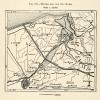
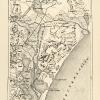
This is an original 1882 color photolithograph map of the British Isles, including, but not limited to Scotland, Ireland and England.
CONDITION
This 129+ year old Item is rated Very Fine +++. Light aging throughout. Light wrinkling. No natural defects. No surface rub. No tears. Light water staining. Please note there is an original crease that extends across this lithograph. Also, please note there is mild creasing on this lithograph.
- Product Type: Orig. Photolithographed Map; Color
- Grade: Very Fine +++
- Dimensions: Approximately 9.75 x 13 inches; 25 x 33 cm
- Authentication: Serial-Numbered Certificate of Authenticity w/ Full Provenance
- Protection: Packaged in a custom archival sleeve with an acid-free black board (great for display, gift-giving, and preservation)
Keywords specific to this image: Wales, United Kingdom, English Channel, Irish Sea, Isle of Man, British Islands, Political Map
XGS6C82
Related products
Sale

Original price was: $6.99.$5.17Current price is: $5.17.
Sale
Original price was: $59.99.$53.99Current price is: $53.99.
Sale
Original price was: $49.99.$35.49Current price is: $35.49.
Sale
Original price was: $49.99.$40.49Current price is: $40.49.